Monday, September 26, 2011

Morrow Mountain - Laurel Trail - 9/24/2011

Laurel Trail
Loop
0.6 miles
Easy

We are working our way through all the trails at Morrow Mountain State Park.  We're just getting started in our quest and are hiking the short easy loops.  The Laurel Trail was the second hike of this day. The first trail we hiked was the Three Rivers Loop Trail.  The other trails we have hiked so far are the Quarry Trail and the Morrow Mountain Loop Trail.

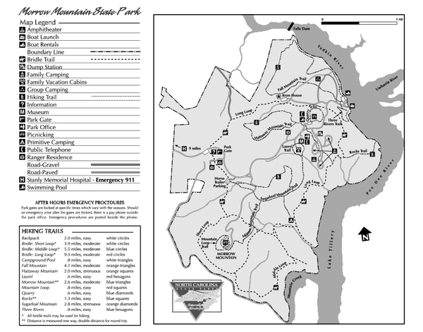
Morrow Mountain Trail Map

Full size map available at:  http://www.ncparks.gov/Visit/parks/momo/pics/parkmap.pdf

The Laurel Trail is only 0.6 miles long and is rated as easy.  It starts in the corner of the parking lot next to the museum with a short connector trail.  We chose to hike the trail clockwise, so at the branch, we took a left.  The trail winds its way in a short circuit through the woods between the cabins and the museum.  In the process it goes up and down small hills with no major elevation changes.

At one point, the trail follows a small stream.  Actually, it was a small trickle, but hey, it's still a stream/creek/brook.  We saw our only wildlife of the trip along side of this trail in the form of a rather large spider hanging on a web right next to the trail.  Next to snakes, spiders are our least favorite things.  So we took his picture and then gave him a wide berth.

 One place worth noting, though not really a big deal at all... If you are hiking counter-clockwise, there is one place where the trail seems to go straight, but in reality, turns a sharp right along the creek.  Going straight leads up to the cabins and even if you go that way, it's a very short detour.  But, you have been warned.

This is by far my favorite trail so far at Morrow Mountain.  The rolling terrain and varied plant life made it an interesting hike.  I am hopeful that the other trails will provide this kind of enjoyable hiking.  My only complaint is that the trail is too short.  It was done in no time and only left me longing to keep on going.

Morrow Mountain - Three Rivers Loop Trail - 9/24/2011

Three Rivers Loop Trail
Loop
0.8 miles
Easy

On Saturday, we continued our bid to hike all of the trails at Morrow Mountain State Park  in Albemarle, NC.

Morrow Mountain Trail Map

Full size map available at:  http://www.ncparks.gov/Visit/parks/momo/pics/parkmap.pdf

The weather was mostly pleasant with temperatures in the mid-70's.  We came in just ahead of a rain front but didn't get any rain while we were hiking.  The recent rain had caused the humidity levels to climb, so that while the temperatures were nice, it was a bit muggy.  On a couple of occasions, there was a nice breeze for which we were very thankful.

The Three Rivers Loop Trail is 0.8 miles of easy walking on a well worn path.  If you are seeking solitude, look elsewhere.  The trail starts at the boater put-in parking lot, crosses the main road leading to the parking lot, and then splits.  If you turn left as we did, it follows the road for the first couple hundred yards.  After that, the trail follows the river for a quarter mile or so.  In both cases, on any warm day, it is likely to be noisy from boaters coming and going in their cars and running back and forth on the water.  It ranges from annoying to downright awful.

After the trail leaves the river, it does provide a little bit of solitude, but the sound of the trucks and boats was always ringing in the air.  It climbs a small knob from which you can see the river through the trees.  Then there is a steep downhill grade to get down off the knob.  Once down to the bottom "typical" trail level, there is almost no gradient change at all.  The loop finishes where you started (Obviously) with a short trip down the connector trail.

With the recent rain, the lower portions of the trail had puddles, but all of them could be circumvented without getting too wet. Iwould not recommend this trail in the summer because I am sure the mosquitoes to humans ratio would be astronomical since it is mostly in a low lying wet area with lots of standing water and tall grass. 

The trail has markers that correspond to a guide of some sort that we didn't have with us.  I would assume it is identifying the trees.  We may have to hike this trail again some time with the guide so I can start teaching the boys (and learning myself) what the different kinds of trees look like.

Conner tripped on a root near the top of the knob and hurt his knee.  He wouldn't let us look at it, but after a few minutes, he recovered enough to start walking again.  Within a short space of time, he was not even limping.  No harm, no foul.

Elijah did pretty good.  Only one restroom break, and not nearly as much "Can we rest now?" and "Can I have something to drink?"  We did make him ration his drink so it would last for both trails we had planned to do.  Next time, I will bring more fluids.  I didn't do a proper job planning for this hike.  I got a bit complacent because I knew it would just be two short trails.

We saw a huge turtle (tortoise?) in a tributary.  It swam out from under a footbridge and hid under some roots.  Unfortunately, Kristina missed it.
.
Pictures coming soon.  Check back later

Wednesday, September 21, 2011

Appalachian Trail (Clingman's Dome) - 9/3/2011

While at Clingman's Dome Labor Day weekend, I FINALLY got to walk (a very small) portion of the AT.
To say I've been obsessed with the AT for the last year or so would be a gross understatement. I've read books, watched movies and documentaries, dreamed, schemed and plotted. The hard truth is that I will probably never be financially able to do a thru-hike. Bummer!
For Kristina and the boys, it was just another trail. Kristina knows of my obsession, and she was excited because of that. For me, though, it was invigorating. I imagined myself crossing that spot on my way to Maine.
We only walked about 100 yards on the trail, but it was the best 100 yard hike I've ever made. Okay, that's really hokey and silly. I guess it would be like test driving a BMW or Porsche. It's drives just like any other car, but it is NOT just like any other car.
There was another peak about a mile south on the AT and I contemplated hiking over there and back, but I knew Kristina wouldn't want to and it wouldn't have been fair to ask her to just sit and wait.
I'll get back to it. I'll do little sections now and then. As the boys get older and more able to do longer stretches and more difficult trails, we'll do more. In the meantime, to all those who do get to hike the AT from GA to ME (or the other way around), hike a mile for me.

Tuesday, September 20, 2011

Clingman's Dome - 9/4/11

Clingman's Dome Access Trail
Out and Back
0.5 miles each way
Very Steep

My first trip to Clingman's Dome was when I was about six years old.
At least, that's the first trip I remember. I don't really remember the actual summit all that much, but on the way back down Clingman's Dome Road, my dad saw a sign on the side of the road that said, "Noland Divide Trail. Deep Creek Campground. 16 miles". (The sign is different now)
Being that it was only a little after lunch and we had no food, water, maps, or supplies of any other sort, my dad thought it would be great fun to walk back to Deep Creek Campground where we were camping. When I say we, I mean him, my mom, my two older brothers (early teens), and myself. The people who were camping with us obviously agreed with his sentiment and it was settled. They drove the car back to the campground, and we set out into the wilderness. My memory of that hike involve my dad singing to "sooth the savage bears", a couple of hikers who gave me some cheese and water (did I mention we had no supplies?), nearly losing the trail because it became so faint (did I mention we had no map?), it getting dark while we were still in the woods (did I mention we had no supplies? Flashlights, anyone? Nope!), and the headlights of the rangers out looking for us when we got to Deep Creek Trail. Looking at maps now, either the Nolan Divide Trail didn't come all the way down to the campground as it does now, or we took a wrong turn at the only intersection on the entire trail and ended up on Deep Creek Trail (Map? NO! We didn't need no stinking map!). At the time, I was scared, hungry, tired, and lost. But it was my first great adventure. Sadly, there have not been enough of them in the years since then. I hope to instill that same sense of adventure in my youngest boys, but with better preparation.
A few years back, I hiked the Nolan Divide Trail with my son Chuck. It is one of my favorite memories with him. I wish we'd gone a little slower. I wish we'd walked the extra 1/4 mile to Lonesome Pine Overlook. I wish we'd gotten a better view of the bear cubs we flushed out. (They tell you bears run fast, but until you see it in person, in the woods, you have no concept of it). I wish I'd known about blister prevention. But live and learn, right?
This past Labor Day weekend, Kristina and I took the boys camping at Deep Creek. Sunday morning, we took the boys and went to Clingman's Dome. The drive up is always fun for me. I like curvy roads. After turning on Clingman's Dome Road, we saw a bear. It was a scrawny looking bear, but it was a bear. The boys thought that was very cool, but Kristina was really excited about this. She always likes to see unusual animals, except snakes. We stopped in the road for a while took some pictures. Then we ended up turning around and driving back to where it was three times before it disappeared into the woods. Kristina mentioned the bear to the volunteer in the gift shop and he said he had seen a whole group of them on the way in that morning. Here are a few pictures...
We were early enough in the day to get a decent parking spot. We got out, made use of the privy's, and then went toward the trail. Trail... This is hardly a "trail." It's a paved road all the way to the top of the mountain. But you do have to walk it, so I guess technically, it's a trail... At the corner of the parking area, there is a mound of rocks. The boys and I spent a few minutes climbing around on the rocks. Conner had a blast doing this, but Elijah only went up about ten feet and parked himself. He wouldn't go any higher.
Then we hiked up the hill. Kristina (me, too) made use of every single bench. I'm not sure how many there were, but we sat on all of them. Kristina commented that she didn't feel so bad after seeing the teenagers and young adults who were struggling just as much as she was. A couple times, I put my hand on her back and helped her walk. At least, I hope it helped. She never said it didn't. Elijah, of course, wanted to stop and rest, but it's funny. When we stopped to rest, him and Conner would start climbing the bank of the trail.
We saw bear scat during one rest. It was just off the trail near the trees. There's no way we would see a bear with so many people around, but it was cool to know they were there.
After what I'm sure was an eternity for Kristina (and Elijah), we made it to the top of the hill.
Actually, I have to brag on Kristina. She's not a hiker. It's just not her thing. But she never complained, and she did really well walking up this extremely steep hill. She was a good sport all day except when I suggested hiking to GA or Maine on the AT. More on that later...
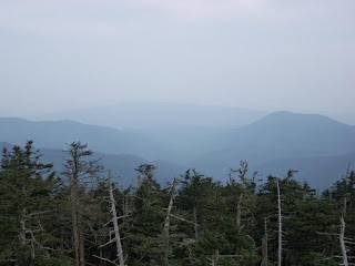
We made our way up the concrete ramp to the Dome. There were a lot of clouds so the views weren't spectacular, but it was still very nice.
The boys got bored pretty quick, so we took some pictures and then made our way back down. Here's some pictures from the trail...
I have to say that the trip down the hill was much easier than the trip up the hill was. Imagine that! We even skipped a couple benches on the way back down.
We stopped at the gift shop and bought the boys a couple stuffed bears. Elijah named his Berry Bear. Conner named his Bryson Bear. Conner and I climbed on the rocks some more while Elijah sat about ten feet up and waited.
When we left, there was a line of cars circling the parking area waiting for a place to park and people were parking a half mile down the road and walking up. It definitely pays to get there before noon. The earlier the better... especially if you hope to see bears.
Morrow Mountain - Quarry Trail - 9/17/2011

Quarry Trail
Loop
0.6 miles
Easy

Since I had never been to Morrow Mountain before, after we finished the Morrow Mountain Loop Trail, we decided to drive around the park to see what was there.

Morrow Mountain Trail Map

Full size map available at:  http://www.ncparks.gov/Visit/parks/momo/pics/parkmap.pdf

We found the museum first. This was an interesting little museum with exhibits about the geology and biology of the park. They had several video monitors set up that played videos for those interested. They also had a relief map of the park which I found very interesting. We would have spent more time there (Conner didn't want to leave), but Elijah had to go poop. There are no bathrooms at the museum, so we got in the car and headed toward the campground where we knew we would find bathrooms.

The campground turned out to be nicer than I expected. The bathrooms (first stop, of course) were clean and modern. The sites were close together, but not on top of each other. The tent pads were mostly level. We may go there before it gets too cold and spend a night or two. After taking care of business, we continued through the campground and started seeing deer. In all, we saw about 12 deer IN THE CAMPGROUND! They were obviously used to people being there.

One group of deer were right next to a rather elaborate camping setup. I imagine that people feed the deer in spite of the signs and warnings not to do so. When we rattled a bag in the car, they came within ten feet of the car. One striking thing about all of the deer was that they were amazingly skinny. I figured they would be putting on weight at this time of the year (I'm not a deer expert. Just common sense reasoning. I could be completely wrong.)

Truth is, I didn't see a single deer that would be worth shooting for the meat. Some might argue it's because they have been fed human food so much that they no longer possess the ability or desire to eat their normal foods. It might could also be argued that they are suffering because of the lack of rain this year. I don't know. I just know they looked pitiful.


Did we feed them? Of course not. The sign said not to, right?

After driving through the campground, we made our way down the other roads and ended up at a huge parking lot that was completely empty. We parked next to the sign indicating the trail head for Quarry Trail.

Quarry Trail is a little 0.6 mile loop trail that runs next to a (dry) creek bed. While there were no "views" per se, it was a nice hike through an interesting forest area. We hiked the trail clockwise.

It started out down a small hill where it met up with the creek. The trail followed the trail downstream and crossed on bridges several times. Since the creek was dry, it wouldn't have mattered much if the bridges weren't there. In a few places, there were trees down over the creek. The boys enjoyed walking across a couple of them.

Actually, there were lots of trees down in this area. It was disturbing how many. They are the result of Hurricane Fran which caused severe damage to the park in 1996. Most of them are in the latter stages of decay, but the evidence of the storm will still be there for years to come.

The best part of this hike for the boys was climbing the hills on both sides of the creek. I challenged Conner to the first one thinking he would slide back down. But instead, he climbed all the way to the top as if it were nothing. Elijah climbed a few hills that were not quite as steep. They both thought that was really cool. We learned of Conner's love for rock climbing at Clingman's Dome. Elijah is not as bold as Conner, but I think that next year, he'll be right there next to his brother, climbing everything in sight.


At one point, there was a near-vertical wall next to the trail. Again, I challenged Conner to climb it. Again, he made it to the top with relative ease. I stood at the bottom of the eight foot high wall in case Conner fell. He was very excited. I'm going to have to take Conner down to the Charlotte Whitewater Center and let him climb the walls down there. Maybe get some lessons. Elijah wouldn't even try.

As we continued to follow the trail downstream, the thought entered my mind that with all that down hill, we'd have to be going up hill eventually. Sure enough, the last couple tenths of a mile were on a slight up hill.

The trail is rated easy, and it was, but Kristina didn't like the up hill part at all. Elijah just wanted to get back to the car and rest.

We played football in the empty parking lot for a little while and then headed home.

We had a nice relaxing day in the woods. I'm thankful for the time I got to spend with my kids and my wonderful wife in God's creation.

There were a couple times that Conner asked when we would get to do some longer trails. Elijah and Mommy were quick to take a pass on longer trails. So they agreed to let Conner and me go on longer hikes without them. I think Elijah will come around when he gets a little older. I admit that hiking just might not be his "thing" and I suppose that's okay. I won't push him to go when he doesn't want to.

Kristina, though, is a different story. I think she will be glad for the easy hikes, but will always take a pass on the harder ones. We are a family divided... can anything ever bring us back together??? Just kidding. We are a very close family and nothing will ever tear us apart... not even an AT thru hike.

Morrow Mountain - Morrow Mountain Loop Trail - 9/17/2011

Morrow Mountain Loop Trail
Loop
0.8 miles
Easy

After a long summer with no hiking whatsoever (except Clingman's Dome a couple weeks back) because of the brutally hot weather, and time and money constraints, Kristina and I decided to take the boys to Morrow Mountain since the temperature for the day was to be in the mid-seventies. There was a slight chance of rain, but it looked like a very slight chance. Turns out we were right and never did get rained on. We chose Morrow Mountain because it is relatively close to the house... less than an hour drive. I had never been to Morrow Mountain and didn't know what to expect of a "mountain" in Albemarle, NC. As it happens, Morrow Mountain fits the bill quite nicely, all things considered.

Morrow Mountain Trail Map

Full size map available at:  http://www.ncparks.gov/Visit/parks/momo/pics/parkmap.pdf

We left the house about 11:00am. After a stop for lunch at McDonald's in Rockwell, we made our way to the park. Thank God for GPS devices because there was a celebration at Biden Lake and we had to detour around the normal route which was inaccessible due to a large block party.
Once in the park, the road winds all the way to the top of Morrow Mountain. While the mountain itself isn't all that tall (936 ft above sea level and only about 400 feet above the base), it appears mountainous because there's not much else of any height in the area. This is what makes the molehill seem a bit like a mountain. The views go on for miles. Also, once in the trees, it's easy to pretend that you are actually up in the mountains. It has a "mountain" feel to it.
We drove to the top of the mountain and got out to find it quite cool and breezy. The boys and I were warm in our hoodies, but Kristina's long sleeve tshirt left her a bit chilled. I offered my hoodie, but she wouldn't have anything to do with the idea. Once we started hiking, she warmed up quickly. The first thing we did was walk to the top of the mountain and take a picture of the boys for their peak bagging list. The we found the start of the Morrow Mountain Loop Trail. This trail starts at the end of the parking area and circles most of the way around the mountain about 30 yards below the road/parking lot, then cuts back uphill to the lower end of the parking lot. And it does all this in 0.8 miles. There's not much to see looking up the hill, but looking out from the mountain provides some nice views. The sky was cloudy the day we were there, so the views were shorter than they would be on a sunny day, but it was still rather nice. Elijah has not yet hit his stride with the hiking thing. For all his excitement about going, we hadn't gone a 100 yards when he wanted to know if we could take a break and eat something. It seems his favorite trail activities are eating, drinking, and resting... not necessarily in that order. I'm hoping that he'll toughen up by next spring/summer and want to do longer hikes. About halfway through the trail, there is evidence of a fire that burned a significant part of the South East side of the mountain back in April, 2010. Somehow, I never heard about this fire.
With many of the trees burned and dying, brush was starting to grow up around the sides of the trail. It will take many years for the forest to reclaim that side of the mountain, and I expect in a couple years, unless the rangers keep the brush cut, there won't be many views along that stretch. For now, though, the views there are spectacular (for a 936' mountain). Just before the trail cuts back and works its way up to the parking area, we stopped at a bridge over a wash out (a drainage ditch for the parking lot) and took a "much needed rest."
Elijah ate an apple while Conner and I explored the rocks in the ditch. They were moderately interested to learn that the indians had used the rocks from Morrow Mountain to make arrow and spear heads. The rock there is Rhyolite which breaks off in thin layers with sharp edges. It's easy to see why they chose to make arrowheads from this rock. We made our way back to the car and Elijah was SO relieved to have FINALLY made it back. We gave him a juicebox and some cookies. Then he was happy. Life is good.... Imagine if you can, how his little world crashed around him when he found out we were going on ANOTHER HIKE THAT SAME DAY! (Some pictures in this post were scavenged off the internet. Shhhh! Don't tell anyone!)

Wednesday, September 14, 2011

Chattooga River Trail - Ellicott Rock - 4/2-3/11

Chattooga River Trail - Burrell's Ford Road to Ellicott Rock
Out and Back
4.3 miles each way
Moderate

April 2-3, 2011 This past weekend we went backpacking with Matt, Beth, and Matty Brayley. As this was the first real backpacking trip for all of us, we chose the Chattooga River Trail from Burrell's Ford to Ellicott Rock (the corner of NC, SC, and GA) which, by all accounts, was an easy hike with minimal elevation change.
This section of the Chattooga River Trail is four and a half miles following the Chattooga River on the South Carolina side. As advertised, it was generally easy hiking with a few steepish spots and some places that were walking through roots and over slick rocks. We met early on Saturday morning. My GPS did not do a very good job of getting us there and at one point wanted me to drive into someone's back yard. After several "Find Alternate Routes", we made it to Burrell's Ford Road. We nearly missed Matt and Beth, but as we were driving by a trail head (for the wrong trail), I saw Matty run out between cars. We figured out where we were and where we needed to be and proceeded to the trail head for the Chattooga River Trail.
The first part of the hike was through an open forest. It was level, smooth hiking. It wasn't right next to the river, but close enough to see it through the trees from time to time.
About two miles in, we came to a large level area that makes for a great camping spot. There were camp sites right next to the river and lots of room away from the river in which to camp. The northern border was a creek that fed into the river. We talked about stopping there, but decided to press on. Later on, we decided we'd have liked to have that decision back.
There was a very nice bridge crossing the creek. Across the bridge, the Chattooga River Trail goes left and continues north while the Foothills Trail splits off to the right (east).
After this bridge crossing, the trail took on a different character. It became narrower, more rocky and rooty. Also, the trail ran closer to the river. There were a couple places that the trail was narrow and a bit tricky with a 15 - 20 foot drop into the river (through the trees and brush, of course). In those areas, we held on to the pack straps of Elijah and Matty. Also, the trail was not as level as the first two miles had been with lots of little up and downs that made the kids "tired."
There was a small creek that was only a problem because we were trying to not get our feet wet. Most of the year, this crossing is probably not even noteworthy, but on our trip, it was too much for the kids to get across without getting wet. So Matt and I took turns carrying packs and children across the creek. We did this coming and going. The kids had lots of fun. Each time we would stop to rest, they would spend their time throwing rocks into the water.
Since we had never been on this trail, none of us knew what to expect or exactly how far it was to the campsites we were looking for. We had read that there were several nice campsites just past Ellicott Rock. With three small children, and Beth being pregnant, we debated turning around and going back to the sites that we had passed earlier in the day. It was a difficult decision in that the trail had been hard and going back was not appealing. Our concern, though, was that we would hike another mile and not find a camping area and have to go even that much further back. We decided to push on. About a half mile later, Beth cried "Mercy." As we debated what to do, a couple of hikers came from the direction we were headed and told us the campsites were just another quarter mile ahead. With relief, we pushed through the last little bit and found a beautiful campsite right next to the river.
We set up camp as the kids played in the water and around the site.
We built a fire and made dinner. As it was getting dark, the kids were playing some sort of war game when Elijah started screaming bloody murder. We ran to him and discovered that he had ran into a knot on a low hanging branch and made a pretty good hole in his noggin. Thankfully, Matt brought a good first aid kit. (Note to self: Improve your first aid kit before going on another trip.) He is also a trained First Responder. I held Elijah while Matt cleaned him up and bandaged him. The wound wasn't nearly as serious as Elijah thought it was, but it bled like crazy.
There was a nice chill in the air that night, and we all slept soundly, huddled deep in our sleeping bags. The boys slept with the draw strings all the way up and their heads tucked inside the bag. Aside from the hard ground, which my old body doesn't care much for, I slept rather well. The next morning, we packed up and headed back down the same way we came in. Everyone was tired and it seemed like a long walk back to the car, but all in all, it was a good trip. It was especially good to see Matt and Beth and see the three boys play so well together. As before, the boys slept all the way home.